Trails
The Peak District GeoWalk
The GeoWalk is a must for rock enthusiasts guiding you through the stunning Peak District landscape and rock formations.
About
The GeoWalk is a long-distance 130 miles / 215 km route. that may be enjoyed as a challenge over the course of 6-8 days, or as a series of separate outings. The journey through the Peak District includes the best of the stunning views, many of the finest landforms and all of the major rock types in the Peak District.
In the Peak District you’re never very far from local facilities and transport links, so it’s simple enough to tackle the walk in whatever form suits you best. The GeoWalk provides a series of interesting walking excursions in the area for full details visit peakdistrictgeowalk.org
The GeoWalk is a circuit with a start and finish in Matlock. The walk is divided into 14 sections that are numbered sequentially from Matlock, but in practice the route can be accessed anywhere.
Trail directions
Matlock to Winster. At 20km this is one of the longer sections of the GeoWalk, and involves some quite intricate route-finding and several steep hills. The route will take you past some fabulous limestone cliffs and quarries.
Winster to Parsley Hay. This section of the walk is in limestone country, apart from a brief excursion onto the overlying sandstone and shale around Harthill Moor. Typical White Peak scenery is first encountered in Bradford Dale, closely followed by Lathkill Dale with its crystal-clear river. The steep path up from the river to reach the limestone plateau provides the only significant climb of the day and then it is level going to Parsley Hay.
Parsley Hay to Milldale. An easy walk along a former railway track and through dales with limestone underfoot almost all the way. After a short excursion to view some of the youngest Peak District rocks in the disused sand pit at Hartington Meadows, the route proceeds to the village of Hartington with all its amenities. From here the walk follows the course of the River Dove along good paths which can be quite muddy in places.
Milldale to Wetton Mill. The route begins with an easy well-marked path following the limestone valley of the River Dove through Dovedale and across the famous stepping stones, with impressive exposures of carbonate mud mounds along the way. The walk then veers away from the Dove to join the Manifold valley at Ilam, skirting the fringes of the Early Carboniferous lagoon and passing onto thinly bedded, muddier limestones that formed in deeper water beyond the lagoon margin. The second half of the walk mainly follows the course of the disappearing River Manifold before ending at picturesque Wetton Mill.
Wetton Mill to Upper Hulme. This section leaves the limestone-dominated lagoonal setting behind and instead traverses over shale, limestone and sandstone that were deposited in deeper water. The route crosses an interesting geological structure as it follows the River Hamps, before climbing to the Mermaid Inn with its wonderful panoramic views. A gentle descent over landslipped terrain to reach the Churnet valley and Upper Hulme concludes the walk.
Upper Hulme to Flash. Starting with the ascent of Hen Cloud and a magnificent ridge walk along The Roaches, the route then follows the River Dane to Three Shire Heads before striking across open moorland which is rather exposed. This section encourages a look at some Dark Peak sandstones at a variety of scales and shows how folded, faulted and landslipped rocks impact the landscape. Towards the end of the walk there is evidence of bygone mining activity in the little-known Buxton coalfield. By the time you reach the remote village of Flash you will undoubtedly appreciate that tough, resistant rocks often produce challenging walking terrain.
Flash to Brierlow Bar. This is a short but moderately strenuous section that starts with fabulous views across typical Dark Peak scenery created by folded Late Carboniferous sandstones and shales that underlie the headwaters of the Manifold and Dove rivers. Careful way-finding is required as the route is not always obvious. As you leave Booth Farm the landforms change dramatically because the Early Carboniferous limestones are encountered again. In poor weather you may choose to avoid the steep and slippery slopes of Chrome Hill and Parkhouse Hill. Beyond those soaring fins of limestone there are two more stiff climbs before you reach the high limestone plateau, skirt around the enormous Hindlow Quarry and descend to Brierlow Bar.
Brielow Bar to Tideswell. A relatively easy walk punctuated by two short steep climbs and a rather treacherous descent towards Topley Pike Quarry. The route passes through several limestone dales, only one of which contains a permanent water course, the Wye, which is one of Derbyshire’s loveliest rivers. Throughout the walk there are interesting igneous rocks to be seen, at scales that affect the landscape. These rocks show that many volcanic eruptions took place during mid-Carboniferous times, forming extensive lava flows and layers of volcanic ash amongst the limestones and shales that were steadily accumulating in the sea.
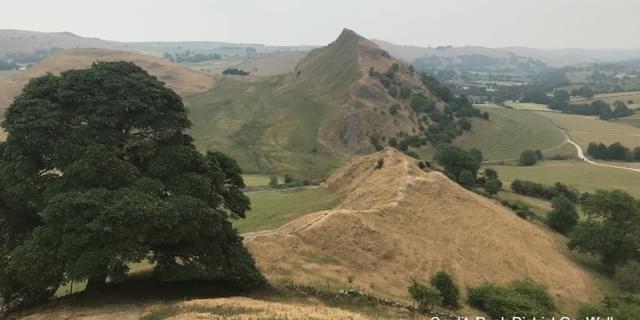
Tideswell to Edale. A truly magnificent walk, starting with a level stretch out of Tideswell that passes through areas on the limestone plateau that were extensively mined for lead. Then there is an attractive descent through Cave Dale, a dry valley at the edge of the limestone plateau that ends up in the village of Castleton. The limestone margin is revisited during the steady pull up Winnats Pass and then younger shales and sandstones are seen along the Great Ridge, before descending to Edale. Along the way there are also interesting exposures of volcanic rock and a traverse across the ‘Shivering Mountain’, one of Britain’s best-known landslide features.
Edale to Birchen Clough Bridge. The first two-thirds of this section coincides with the start of the Pennine Way, one of the most popular walks in Britain. Route-finding is straightforward, but you need to be cautious in poor weather because Kinder Scout is a high and exposed plateau. The GeoWalk follows a typical Dark Peak rock succession of resistant Late Carboniferous sandstones with some interbedded shales that are overlain by much younger superficial deposits.
After a gentle start along an old packhorse route around the flanks of Kinder Scout there is a stiff climb to the plateau, the western edge of which is then followed to Ashop Head. The path down Ashop Clough is rather rough and often quite wet, but the finishing stretch through the forestry plantation in Snake Pass is pleasant enough.
Birchen Clough Bridge to Fairholmes. A short and straight-forward walk through some of the lower-lying Dark Peak countryside that offers little in the way of geological variety, but nevertheless encounters lots of interesting landforms. The route starts by following part of a Roman road that used the Woodlands Valley to traverse the high Pennines. Then, at Hayridge Farm the GeoWalk heads north to reach the spectacular landslide at Alport Castles, an atmospheric place that is relatively isolated and full of features that appear rather other-worldly. Now beyond halfway you can stride out over Rowlee Pasture, which offers fine views to the south and west, before dropping down through Lockerbrook Coppice to reach the Peak District National Park Visitor Centre and car park at Fairholmes.
Fairholmes to Upper Burbage Bridge. A stiff ascent out of the Derwent valley takes you over successively younger sandstones and shales belonging to the Late Carboniferous Millstone Grit succession. When you reach the high point at Back Tor, contour around Derwent Edge which is formed by resistant Kinderscout Grit. Here the walking is easy and invigorating, enlivened by wonderful views and improbably-shaped tors. A gradual descent down the dip slope brings you to the A57 at about the halfway point. The second climb of the day takes you to the top of the overlying Chatsworth Grit, exposed here as the incomparable Stanage Edge. There a few finer places to walk than along Stanage, a popular recreational destination where you will find company in all but the most adverse weather. This final stretch is quite long and you will feel well exercised by the time you reach the car park at Upper Burbage Bridge.
Upper Burbage Bridge to Robin Hood Hill. This walk is unique in that it follows one very prominent rock formation for the best part of fifteen kilometres. The Chatsworth Grit Formation is primarily made up of sandstones with some thin interbedded shales, with the sandstones becoming thicker and more extensive towards the top. It is this upper part that commonly forms the bold scarp faces or ‘gritstone edges’ that characterise the eastern margin of the Peak District. Continuing the theme established at Stanage Edge, this section follows four more edges, all geologically similar and offering great walking. Starting at Burbage, the walk heads south along the scarps of Froggatt, Curbar and Baslow, interrupted only by a couple of deep valleys that cut through the sandstone capping at Padley Gorge and Bar Brook.
Robin Hood Hill to Matlock. This walk has a demanding start as you grapple with way-finding and the terrain alongside the Heathy Lea Brook, before ascending the Crawshaw Sandstone scarp to find much easier ground on Gibbet Moor and Beeley Moor. These eastern moors provide exceptional evidence for prehistoric settlement, fields and cairnfields, so there is more than geology to hold your interest. The descent into Two Dales leaves the long association with sandstone ridges behind and you get a sense of returning to the White Peak as you approach Matlock. It’s the journey’s end, or perhaps its start – take your pick!
Sign up to our newsletter
Receive the latest news, special offers, ideas and inspiration straight to your inbox by signing up to the Visit Peak District & Derbyshire e-newsletter.
