Trails
South Derbyshire Walk – Peek into the Past
An easy 6 mile walk, with lar reaching views, to the tranquil riverside village of Swarkestone.
About
An easy 6 mile walk, with far reaching views, to the tranquil riverside village of Swarkestone - through a landscape carved through by river, canal and railway. Download the pdf above for route details.
Starting Point: Melbourne, Stanton by Bridge or Weston-on Trent. Parking: In car park in Melbourne town centre. Refreshments en route: Crewe and Harpur pub at Swarkestone.
Respect, Protect, Enjoy Whether you're a regular or brand new visitor, we want to make your trip to the Peak District & Derbyshire as safe, easy and enjoyable as possible. Ensure your visit is a responsible one by following the Countryside Code and stay #PeakDistrictProud by keeping dogs on a short lead, parking only in designated areas, sticking to public rights of way where you can, saying no to BBQs and open fires, and taking your litter home with you.
Trail directions
Leave the Market Place and head down Church Street towards the Parish Church past the Spirit & Vaults Pub. Turn left into Castle Street and right into Castle Lane (beyond Castle Farm) them immediately left into The Lilypool. Walk right along Station Road lor a couple of hundred yards then left into Jawbone Lane. At the crossroads with the village cross in Kings Newton go straight over down Trent Lane.
Kings Newton may be an older settlement than the present day town of Melboume. And an important Anglo Saxon cremation cemetery was discovered here in 1867.
Just before a railway bridge veer left down to the railway track, turn left and walk along the track (once a branch line between Derby and Ashby, but closed in 1973), watching out lor bikes, as this is a cycle route too. A few hundred yards past the viaduct over the River Trent leave the track (to the left) and head down towards the canal bank. Turn left along the Trent and Mersey canal (completed here in 1777) and walk for just over a mile until you reach a canal bridge just after a canal mileage marker.
Climb the track by the bridge and turn left along a path which almost immediately takes a turn right across a field. Follow this well marked way for about half a mile t0 the Bullring at Swarkestone - an unexpected and amazing sight in this location.
Sometimes called the Balcony, the Stand, the Pavilion, the Bullring or Bowl Abbey House, this strange building rivals the bridge as Swarkestone's best known structure. Lt was built in 1632 in the style of John Smythson, who was partly responsible for the rebuilding of William Cavendish's fairy tale castle at Bolsover lt served mainly as a grandstand for the bowling green in the rectangular walled enclosure in front (known as 'The Cuttle'), a pavilion to retire to after feasts at nearby Swarkestone Hall (demolished), hone of the Harpur family before Calke Abbey. It has been restored by the Landmark Trust who let it as a holiday property'
From the Bullring head to the back of the parish church, passing on your lelt the 'Tithe Barn', now a house lt’s gardens back onto the site 0f the Elizabethan hall and the walled enclosures once housed gardens.
Swarkestone church was virtually rebuilt in the 1870s, however the 15th century tower and Harpur Chapel are from an earlier building. The font and fragments in the east aisle wall are Norman.
Cross the churchyard and turn left at its entrance gate, ignoring the footpath sign on the other side of the road. Head towards the River Trent and at the riverbank turn right and head lor the Crewe and Harpur pub.
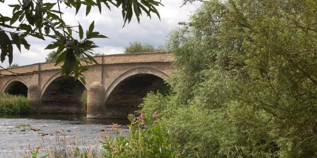
Turn left onto the Georgian bridge and turn right down road signed to Ingleby. You will shortly see a stile on the left by the entrance to the sailing club do not enter the club itself but follow the public footpath through the field around the club alongside Swarkestone Causeway.
Swarkestone Causeway is a scheduled ancient monument ¾ mile long, dating mainly from the 13th and 14th century.
Pick up the path alongside a stream that heads west away from the last arches of the bridge. Mount a stile and continue on the path ignoring the first stile on your left. At the second stile, head uphill and into Stanton by Bridge.
Visit the Anglo Saxon church here if you have time, then head east uphill along the main street until you reach the main road. Cross with care and turn right towards Melbourne. After 200 yards, turn left through a metal gate and head towards the Victorian pumping station Almost immediately join a footpath to the right uphill towards an electricity pylon. Follow this path until it meets a track coming up from the Causeway and keep on this 'laggers' track into Kings Newton. Turn right along the main road - within a few yards a finger post points to Melbourne. Follow this by the backs of the houses and market gardens until you reach Derby Road. Turn left and head back into Melbourne
Sign up to our newsletter
Receive the latest news, special offers, ideas and inspiration straight to your inbox by signing up to the Visit Peak District & Derbyshire e-newsletter.
