Trails
Hathersage to Stanage Edge Walk
A 9 mile walk from the village of Hathersage up onto Stanage Edge and back, with superb views of the Derwent and Hope Valleys, Mam Tor and Kinder Scout.
About
Hathersage to Stanage Edge Walk Route - Visit Peak District & Derbyshire
Starting in the village of Hathersage, this 9 mile walk takes you along the wonderful cliffs of Stanage Edge with superb views of the Derwent & Hope Valleys, Mam Tor and Kinder Scout.
On the way to the Stanage Edge, you will pass North Lees Hall which is a building steeped in history and literary connections. This 16th century manor is thought to have been the inspiration behind Mr Rochester’s home in Jane Eyre. The Eyre family did in fact live there in real life. They were Roman Catholics who lived there until the 17th century until they were driven out by a Protestant family. The remains of their chapel, built in 1685 and destroyed three years later, can still be seen on the grounds.
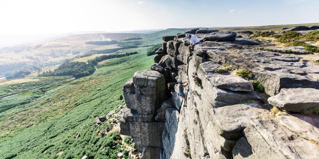
Once you have passed the Hall, you can continue on to Stanage Edge itself. This is arguably the most impressive gritstone escarpment in the Peak District, stretching for 6 km (3.5 miles). Looking beyond the escarpment, you will notice that the landscape is sprinkled with old millstones and grindstones. Both fully intact and broken, these are all discarded relics of a once flourishing industry, since the industry started to move on in the 1860s they were left abandoned, but are now the iconic of the Peak District National Park.
Many people now visit Stanage Edge as part of their Pride & Prejudice pilgrimage. This was one of the filming locations from the recent film adaptation of the Austen novel- these are the very rocks where Kiera Knightly stood looking windswept and pensive.
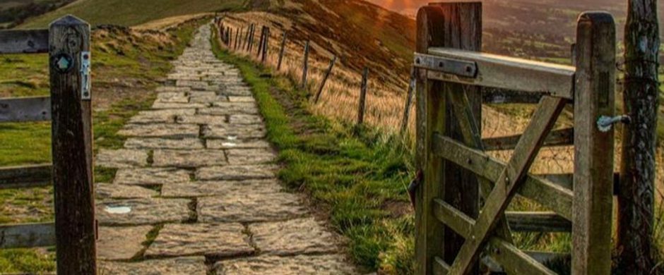
Please download the above PDF for more a detailed description, directions and a small map. Although we have given you an outline of this walk, we do advise people to bring their own map and compass and also to wear good walking boots whenever they walk in the Peak District.
Respect, Protect, Enjoy: Keep it #PeakDistrictProud Whether you’re a regular or brand new visitor, we want to make your trip to the Peak District & Derbyshire as safe, easy and enjoyable as possible. Ensure your visit is a responsible one by following the Countryside Code and stay #PeakDistrictProud by keeping dogs on a short lead, parking only in designated areas, sticking to public rights of way where you can, saying no to BBQs and open fires, and taking your litter home with you.
Trail directions
From the car park go onto the main road (A6187) through the village and take the lane called Baulk Lane which starts on the opposite side of the road to the petrol station, next to the large stone building (formerly the Hathersage Inn). The lane climbs steadily north, passing the cricket pitch. Beyond the buildings it becomes an unsurfaced track. Just short of Cowclose Farm take the signposted left fork, which passes to the right of Brookfield Manor to reach a country lane. Turn right here, then left along a drive to North Lees Hall.
After rounding the hall, turn right, climbing some steps that cut the corner to another track. This crosses hillside pastures before continuing through attractive mixed woodland. A stepped path on the left makes a shortcut to a roadside toilet block and mountain rescue post. Turn left along the road for a short distance, then right on a grassy path heading for the rocks of Stanage Edge. After 200yds (183m) you join the path from the nearby car park. A paved path now climbs through Stanage Plantation before arcing left to the cliff top. Follow the firm edge path north westwards (right) to see the summit of High Neb and Crow Chin.
When you reach Crow Chin, where the edge veers north, descend to a lower path that doubles back beneath the cliffs. This eventually joins a track from the right, which returns the route to the top of the cliffs. Continue walking towards the south east along the edge to the bouldery east summit (marked on OS maps by a spot height of 457m), whose rocks are capped by a concrete trig point, until you reach the road at Upper Burbage Bridge.
Proceed left along the road for about 150yds (137m), then turn right taking the higher of the two paths which head south to the summit of Higger Tor. From the rocky top, double back (roughly north of north west) on a path to the Fiddler’s Elbow road. Slightly uphill along the road take the path on the left. This descends Callow Bank to a walled track leading down to the Dale Bottom road. Follow the road for 300yds (274m) to a track on the right that traverses the hillslopes to Toothill Farm. Turn left by the farmhouse on a drive that soon joins a tarred lane taking the route down to Hathersage’s impressively spired church and the Roman fort of Camp Green. Turn right down School Lane to reach Main Road, which leads into the centre of Hathersage. Go left down Oddfellows Road to return to the car park.
Sign up to our newsletter
Receive the latest news, special offers, ideas and inspiration straight to your inbox by signing up to the Visit Peak District & Derbyshire e-newsletter.