Trails
Bakewell to Chatsworth Walk
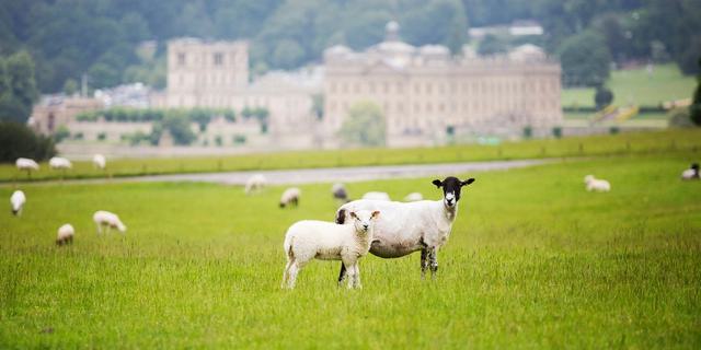
An interesting 6 or 8 mile walk through woods and fields to visit Chatsworth House in its setting beside the River Derwent
About
Bakewell Walks to Chatsworth in the Peak District, Derbyshire
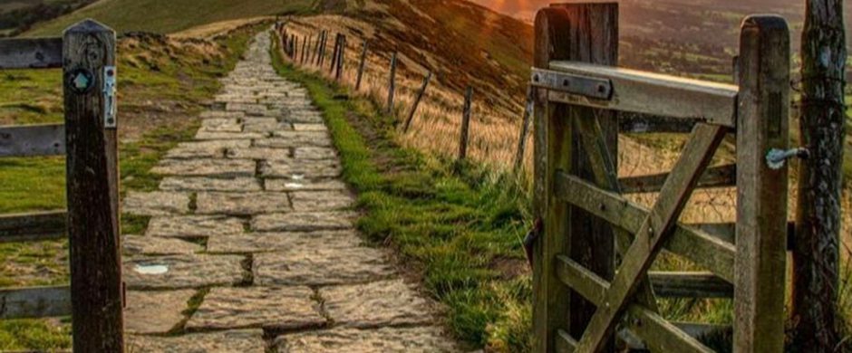
This walk in Bakewell takes you over the Monsal Trail, through some woods and to the picturesque village of Edensor, ending in the gem of the Derbyshire countryside, Chatsworth House. There are some glorious views of the house and the Hunting Tower along this walk, as well as the chance to have a cup of tea and some cake in the traditional tearooms at Edensor, the closest village to Chatsworth itself.
There are two routes, one is 6 miles and one is slightly longer at 8 miles. The longer walk takes you a more scenic route on the way back from Chatsworth, as to include a walk along the River Derwent. This route also includes places of interest such as a ruined corn mill and an Iron Age fort, which comes with another wonderful viewpoint.
This is a brilliant walk to do if you’re staying in Bakewell, or you’d like to combine visiting both Bakewell and the delights of Chatsworth.
Please download the PDF below for a detailed description, small map and directions of the route. Although this is not a challenging walk, please do make sure to bring a map and compass as well as good walking boots for your trip.
Respect, Protect, Enjoy: Keep it #PeakDistrictProud Whether you’re a regular or brand new visitor, we want to make your trip to the Peak District & Derbyshire as safe, easy and enjoyable as possible. Ensure your visit is a responsible one by following the Countryside Code and stay #PeakDistrictProud by keeping dogs on a short lead, parking only in designated areas, sticking to public rights of way where you can, saying no to BBQs and open fires, and taking your litter home with you.
Trail directions
From the centre of Bakewell cross the river over the medieval bridge and turn along Combs Lane. Walk along here until you reach a footpath sign by a gate on the left. Go up the tarmac drive and turn right and continue up the field side to a bridge over the Monsal Trail.
Carry on up right, across the golf course and on a prominent track into the wood. Where a small stream comes down continue up steeply to a ladder stile over the wall at the top of the wood, then head half right for the clump of beech and a pond. Go over a stile by the pond, along its south side to another gate and stile. Follow the grassy footpath for about half a mile, gently downhill keeping just left of the shallow depression to a gate, above a plantation. Carry on through this down a broad track towards Russian Cottage, but turn left before this and a ‘Dutch barn’ at a signpost: Edensor.
Follow this through a gate - a track leads through plantations into Chatsworth Park, where a couple of benches make a pleasant point to stop and view Chatsworth in its setting, with Stand Woods and the Hunting Tower behind. From here head between two plantations for a point just left of Edensor Church. On nearing the village, look for electricity sub-station within a walled enclosure. To the right of this go through an unusual wrought-iron gate at the top of four stone steps, and so down to a tarmac road. Turn right down this road into the village of Edensor. Leave the village through the white gates, cross the main road, B6012, and take the footpath opposite. In a few minutes Chatsworth House comes into view.
From Chatsworth you have a choice of two routes back... a more direct one back through Edensor or a longer one which includes a walk by the River Derwent.
Cross back over the bridge over the River Derwent and turn immediately left, to follow a broad track of grass which does not follow the river but heads almost straight for the next bend in it. From here follow the river along to just after the ruined corn mill building on your right, then walk up the grassy slope to join the road. Cross over the road and follow the tarmac road along the edge of the car park,, towards the garden centre. Keep straight on past the garden centre (refreshments and toilets here) and the road shortly curves to the right, into Calton Lees.
At a small grass triangle keep straight on up a track with a stream on your left. Follow the track up the valley for almost a mile to Calton Houses. The track is a public bridleway and zig zags up between the houses and continues up the valley with a plantation close on the left. Nearly 300 metres above Calton Houses the bridleway goes between this plantation and the next, through a gate on the left where the little stream in the valley sometimes flows over the track.
The way continues on the track waymarked with blue arrows curving round until you are almost walking in the opposite direction for a little way, but it gradually ascends bearing right and opens out, heading almost south up Calton Pastures. Head straight up the slope just right of a shallow depression containing two gritstone troughs. You should see a finger post at the top at the right end of a plantation.
Now turn right and follow the grassy track back to the beeches and pond. Either retrace your steps direct down to Bakewell or continue along the ridge up a slight rise, past the site of an Iron Age fort (fine views from here) to a gate and farm track leading to Ball Cross and a minor road. Turn left down this a few yards then go left down the steep bridleway through the wood and across the Golf Course to the old station. Continue down Station Road into Bakewell.
Sign up to our newsletter
Receive the latest news, special offers, ideas and inspiration straight to your inbox by signing up to the Visit Peak District & Derbyshire e-newsletter.