Location
Welcome to Castleton
Castleton is a beautiful village situated at the head of the Hope Valley in the heart of the Peak District National Park.
Things to do in Castleton in the Peak District & Derbyshire
Close to mysterious Mam Tor, locally known as the 'Shivering Mountain', Castleton is one of the most beautifully-situated villages in the Peak District.
Whether you approach through the dramatic limestone gorge of Winnats Pass or from the Hope Valley, you'll appreciate the fabulous views created by its location on the cusp of the Peak District's breathtaking limestone and gritstone landscapes.
Whatever the weather, Castleton has something to offer visitors of all ages at any time of year. If it's fine and you're feeling fit, climb the steep steps up to the atmospheric Norman ruins of Peveril Castle, completed in 1086 for William Peverel, a favoured knight of William the Conqueror.
Castleton is the only place in the world where the semi-precious stone Blue John, unique to the Peak District and Derbyshire, can be found and there are numerous show caverns to explore
Fortify yourself in numerous cafés, tea rooms and pubs before heading off to tackle the Great Ridge Walk, one of the finest routes of its kind in the country. Plus, there are lots of places to stay in Castleton including hotels, self-catering cottages, B&Bs and more.
Nearby is the pretty village of Hope, mentioned in the Doomsday book as well as Edale the small village that marks the start and end of the Pennine Way.
Other places of interest nearby include the delightful Derbyshire village of Bradwell, which contains clusters of cottages and character houses that spread up the sides of a deep gorge before opening out onto lush meadows in the Hope Valley.
Activities in and around Castleton include paying a visit to Treak Cliff Cavern, an underground wonderland of stalactites and stalagmites, rocks, minerals and fossils. Oaker Farm Cottages & Haddy's Hut is a great choice for accommodation during your stay.
Featured Businesses

Featured
Business
Treak Cliff Cavern
Visit an underground wonderland of stalactites and stalagmites, rocks, minerals and fossils. Home of the unique mineral Blue John stone
Open today: 10:00am - 4:00pm

Featured
Business
Edale Gathering
The Gathering opened in 2016 and has been 5* rated on Tripadvisor ever since. Located at the top of Edale valley on a private farm.
Open today: 10:00am - 4:00pm

Featured
Business
Losehill House Hotel & Spa
Losehill House is the perfect blend of luxurious facilities in the glorious surroundings of the Hope Valley in the Peak District, with stunning views…
Open today: 10:00am - 4:00pm
Highlighted

In The Area
Search
Featured
Business
Edale Gathering
The Gathering opened in 2016 and has been 5* rated on Tripadvisor ever since. Located at the top of Edale valley on a private farm.

Featured
Business
Bike & Boot Leisure Hotels at Bike & Boot
A new Leisure Hotel brand for the 21st century - welcoming walkers, dog owners, cyclists and adventurers to the Peak District

Featured
Business
The Bareca at Bike & Boot Leisure Hotels
The Bareca (Bar-restaurant-café) is open for breakfast, lunch and dinner to both residents and non-residents serving a Mediterranean style menu,…
Featured
Business
Treak Cliff Cavern
Visit an underground wonderland of stalactites and stalagmites, rocks, minerals and fossils. Home of the unique mineral Blue John stone
Featured
Business
Losehill House Hotel & Spa
Losehill House is the perfect blend of luxurious facilities in the glorious surroundings of the Hope Valley in the Peak District, with stunning views…

Business
Oaker Farm Cottages & Haddy's Hut
Three Hope Valley cottages converted from a former dairy and barns to a high standard, along with a luxurious shepherd's hut. Tranquil, peaceful…

Business
Riding House Farm Cottages
Recently converted farm cottages with stunning views over the Hope Valley. Superbly equipped, original beams and features. Situated in an historic…

Business
Food at Yorkshire Bridge Inn
Situated in the beautiful Hope Valley in the Peak District National Park, the Yorkshire Bridge Inn is a family owned multi award winning inn located…

Business
Peak Sightseer open top bus
Soak up the scenery from this open top bus service and visit some of the Peak District’s most popular destinations with stops at Castleton,…

Business
Hope Valley Bike Hire
We have a wide range of bike hire options, for all abilities to explore the Hope Valley and the wider Peak District

Business
Food at Old Hall Hotel
Transformed in 2010 by current landlord Rick Ellison, the Old Hall Hotel in Hope is now firmly established as one of the best places to stay, eat &…
Our Great Itineraries

Day out from Buxton – enjoy the Peak District…
Catch the new High Peak Peak Pathfinder (62) service from Buxton and explore the national park

Day trip from Sheffield: Exploring the Hope…
Offering some of the best views and most picturesque villages in the country, Derbyshire's iconic Hope Valley is one of the best-loved parts of the…
Car-free guide: 48 hours in the Hope Valley
Take in dramatic scenery, quaint villages and some of the Peak District's most iconic attractions along the Hope Valley Line between Manchester…
Experiences in Castleton

Self-Guided Audio Tour of Treak Cliff Cavern
The Cavern is a genuine wonder in the heart of the Peak District. Treak Cliff Hill is the only place in the world where Blue John Stone occurs…
Prices from £14

The Blue John Stone Experience at Treak Cliff…
This truly unique experience enables you to work with Treak Cliff Cavern family and staff to get really “hands-on” with the stone.
Prices from £350

Rock Climbing and Abseiling in the Peak District…
Our climbing and abseiling sessions are suitable for complete beginners through to experienced climbers looking to try new crags.
Prices from £204
Events in Castleton

Events
Tour de France Femmes avec Zwift Grand Départ
Derbyshire is proud to be hosting Stage 2 of this prestigious event


Events
Hope Valley Beer & Cider Festival
Annual beer, cider & live music festival every bank holiday weekend based in The Hope Valley
Trails nearby

Edale to Kinder Scout Walk
This circular walk takes you from the pretty village of Edale to the windswept moors of the Kinder plateau, the highest point in the Peak District.

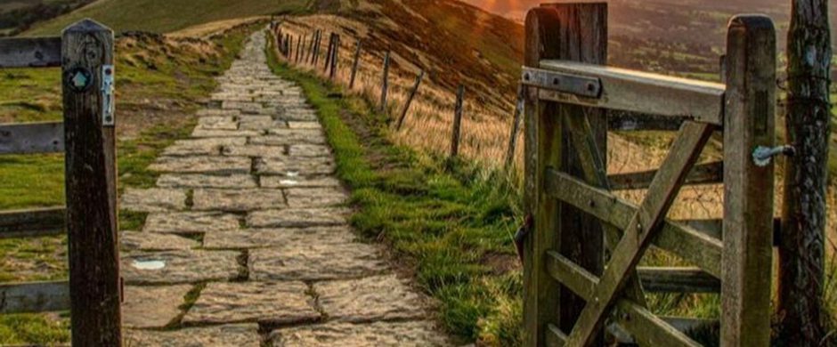
Castleton, Mam Tor & The Great Ridge Walk
An exhilarating 6½ mile walk with the option to extend to 8 miles. It includes one of the best ridge walks in the country, with superb views of the…

The Limestone Way
The Limestone Way is a superb 46-mile waymarked route across the White Peak landscape of the Peak District National Park.

The Peak District GeoWalk
The GeoWalk is a must for rock enthusiasts guiding you through the stunning Peak District landscape and rock formations.
Places to stay

Business
1 Coach House Mews Matlock Bath
From £150 [1 night] *book direct only on 07738 428539. Stylish 2 bedroom ground floor apartment with parking set in an attractive stone conversion…

Business
Alton, The Star Camping and Caravanning Club Site
Close to the rolling hills of the Peak District National Park, our Club Site at Alton, The Star offers plenty of choice when it comes to heading…

Business
Ashbourne Camping Cabin
Our cosy Camping Cabin is perfect if you are looking for glamping accommodation in the Peak District. Occupying a south-facing position overlooking a…

Featured
Business
Ashford Mill
Ashford Mill is an award winning watermill on the River Wye at Ashford in the Water. A Grade 2 listed 3 bedroomed historic conversion. incredibly…
Offers


Special Offer
Save up to 25% on stays at The Bike & Boot
Stay 3 nights and save up to to 25% per night

Special Offer
Fish Fridays at The Bulls Head Foolow
The Bulls Head Fish Friday - Fish & chips with a selected drink for £20.95

Special Offer
Enjoy 10% off food & drink when you travel on the…
Hop onboard the open top bus service this summer and save on meals out at eateries along the way
Villages nearby

Bamford
Bamford is an attractive village and popular visitor destination close to walking routes and the reservoirs.
Sign up to our newsletter
Receive the latest news, special offers, ideas and inspiration straight to your inbox by signing up to the Visit Peak District & Derbyshire e-newsletter.