Car-free walks: Great walks from train stations in the Peak District and Derbyshire
Leave the car at home, pull on your walking boots and hop on the train to discover some of the best walks in the Peak District & Derbyshire that can be easily accessed by train.
Leave the car at home, pull on your walking boots and hop on the train to discover some of the best walks in the Peak District & Derbyshire that can be easily accessed by train. Explore iconic beauty spots in Britain's original National Park, find hidden Derbyshire gems on foot and enjoy great places to eat and drink along the way.
Here, Lucy Thorpe rounds up some of the best walks that start and end at train stations in the Peak District & Derbyshire.
The Peak District & Derbyshire has excellent public transport links to the cities of Manchester, Sheffield, Birmingham, Nottingham and Derby and regular local train services provide a wealth of opportunities for walkers.
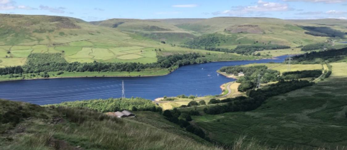
The Hope Valley Line runs between Manchester and Sheffield, giving direct access to popular outdoor stops like Grindleford, Hathersage, Bamford, Hope and Edale. The Manchester to Glossop Line offers access to the dramatic reservoirs and wild moorland of the Dark Peak; the Derwent Valley Line between Derby and Matlock covers the highlights of the UNESCO Derwent Valley Mills World Heritage Site; and the Manchester to Buxton Line allows you to explore the tranquil yet dramatic Goyt Valley on the fringe of the National Park.
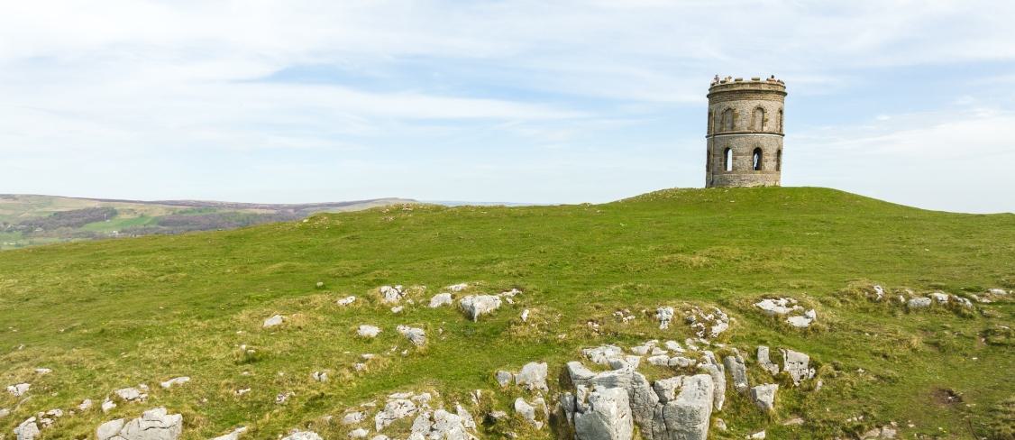
Buxton to Solomon's Temple: 2 miles
A great walk for the whole family to enjoy. Explore the Victorian Folly of Solomon's Temple on the summit of Grin Low hill and enjoy some spectacular views across Buxton on this short, circular walk, which takes around 50 minutes (2 miles). Afterwards, pop into the nearby Poole's Cavern for an underground adventure!
Edale to Kinder Scout: 8 miles
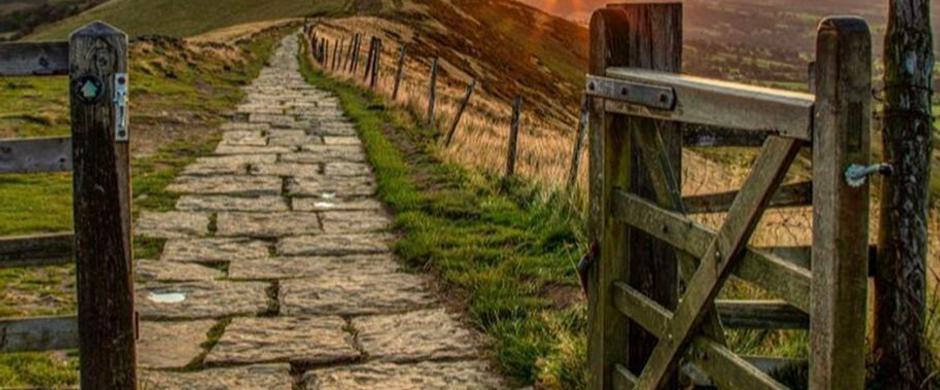
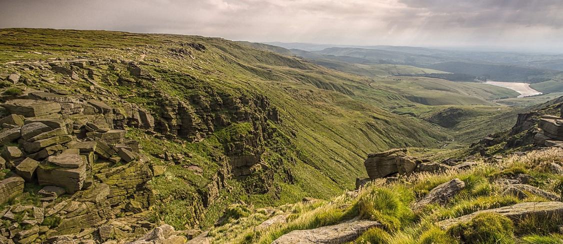
This circular walk takes you from the pretty village of Edale to the windswept moors of the Kinder plateau, the highest point in the Peak District. The route ascends via the rocky ravine of Grindsbrook Clough and then follows the edge of the plateau, passing Crowden Tower, the Wool Packs and the Noe Stool, before descending via Jacob's Ladder and returning to Edale on the final section of the Pennine Way. There are truly spectacular views along the way over the Edale Valley and the western edges of the Peak District.
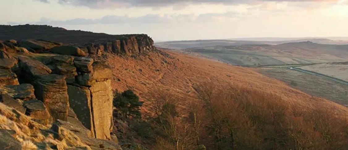
Hathersage to Stanage Edge: 9 miles
Starting in the village of Hathersage, this 9 mile walk takes you along the wonderful cliffs of Stanage Edge with superb views of the Derwent & Hope Valleys, Mam Tor and Kinder Scout. On the way to the Stanage Edge, you will pass North Lees Hall which is a building steeped in history and literary connections. This 16th century manor is thought to have been the inspiration behind Mr Rochester’s home in Jane Eyre. Stanage Edge is also famed locally as a Pride & Prejudice filming location; it's the spot where a windswept Keira Knightley dreamed of her dashing Mr Darcy!
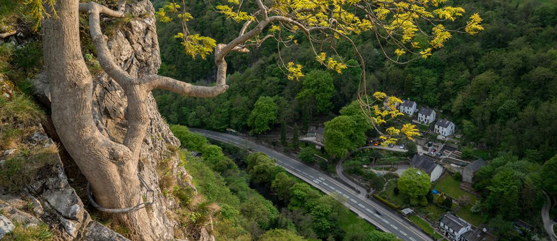
Matlock Bath to High Tor and Giddy Edge: 4 miles
A linear walk with superb cliff-top views, you'll need a head for heights to tackle this breathtaking walk! There are train stations at both Matlock and Matlock Bath, so you can walk from either end, and you could even catch the train back to your starting point if preferred. This walk is considered to be unsuitable for young children due to steep drops and cliff edges and includes fairly strenuous uphill sections, but the views are worth it!
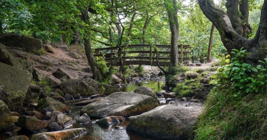
Grindleford to Padley Gorge
This 6 mile walk starts from Grindleford train station, making it very easy to travel to. You'll wander through the picturesque woodland surroundings of Padley Gorge - famed for its brook which flows over rocks and under wooden bridges.
At the train station, walk uphill towards Grindleford Station Cafe. Turn left, and follow the lane uphill as it bears slightly left, before turning off right. Follow the sign for Longshaw Estate via Padley Gorge.
Padley Gorge is a great spot to pause and admire the wildlife and beautiful scenery. When the path splits, take the left fork and walk up the hill away from the water, keeping Burbage Brook on your right-hand side at all times.
Take path through open countryside. Upon reaching the second bridge, turn left to follow a grassy path that runs between large rocks towards a gate beside the road. Through this gate, cross the road (with care), and take the public footpath directly opposite.
Continue along this path, passing through a gate to Hathersage Moor. Take the left fork in the path and after a short distance, you'll spot the iconic Higger Tor rock formation (a former Iron Age hill fort). Continue along this path until you reach a fork next to a bench.
Bear left and climb to the top of the small hill. Next, go straight over the crossroad of paths to walk downhill. When you reach the T-junction of paths at the bottom of the hill, turn left and follow the trail towards the rocky outcrop called Over Owler Tor.
At the next fork in the path, head left and continue straight on, passing Over Owler Tor on the left. Walk uphill, staying on the path instead of climbing the stile. The path will be on the left of the fence with stunning views across the valley to your right.
Go through a gate marked Access Land, where you’ll find a bench with lovely views across the Derwent Valley. Continue walking with the stone wall on your right. Cross the road and follow the public footpath to Lawrence Field. Here, the stone wall will be on your left. Follow it until you reach a gate that takes you back down to Padley Gorge and the path you started on. Retrace your steps to Grindleford railway station.
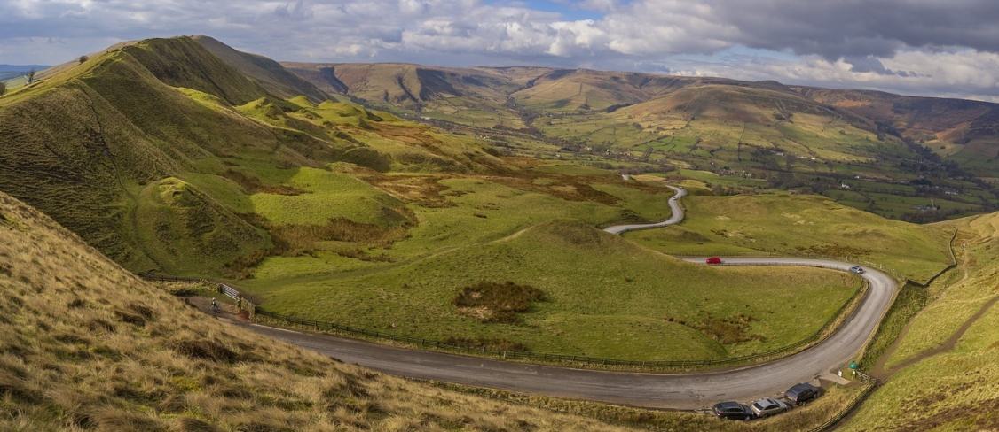
Hope to Edale via Castleton: 4 miles
Both of these idyllic villages are situated on the Hope Valley Line (easy to access from Manchester, Stockport or Sheffield), offering beautiful scenery, impressive hikes and quality places to eat and drink, whichever way around you choose to do the walk. The route takes you through Castleton, famous for its show caverns and caves, and offers great sites to explore along the way such as Treak Cliff Cavern, where you can head in search of Blue John Stone.
It’s a pleasant 4-mile walk between the two villages, with a moderate climb and beautiful views of the Hope Valley along the way. Starting out at Hope near the Church, head south to a public footpath alongside Peakshole Water (part of the River Noe) towards Castleton.
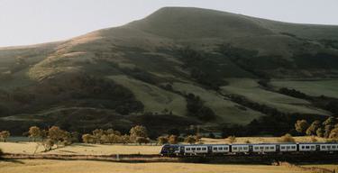
Once in Castleton, head north west and pass Dunscar Farm, climbing to Hollins Cross. This is the lowest point of the Great Ridge between Castleton and Edale and is very popular with walkers, so we recommend enjoying this walk during the week or at quieter times of the year if possible. Don't forget to take your camera to capture the iconic views of Mam Tor and the Hope Valley.
You then start to descend to the idyllic village of Edale, crossing the River Noe en route. From here, you can either catch the train from Edale station back to your starting point, or extend your walk on one of the numerous paths that climb to the Kinder Scout plateau - the highest point in the Peak District National Park.
Hadfield to Longdendale: 9 miles
In the dramatic northern reaches of the Peak District, this walk start at Hadfield train station (accessible on the Glossop Line from Manchester). The route takes you up the Longdendale Valley, across the route of the old Woodhead Railway.
After leaving Hadfield station, go left into the car park and join the scenic Longdendale Trail, a popular walking and cycling route. Follow the trail up though the valley where it meets the road near Woodhead Dam.
You’ll see some amazing views as you head down to leave the trail, following a concessionary footpath that crosses a weir by the dam. You’ll then turn east by the shore of Torside Reservoir for just over a mile, intersecting with the Pennine Way (England's first long-distance footpath) briefly.
Don’t follow the Pennine Way, instead take the lower of two tracks to the north of Rhodeswood Reservoir. You’ll see Bramah Edge and the Devil’s Elbow above you. Once you reach the dam, cross it and follow the tarmac lane by Deepclough.
Follow this until it crosses over the Longdendale Trail, following the signposted path on the right, passing through fields to a walled lane between houses at Padfield. Go right, then take the second left onto Post Street to a T-junction. After this, go right again on Platt Street which leads downhill back under the Longdendale Trail and back to the railway station.
Grindleford to Hathersage: 6 miles
Two of the Peak District's most popular hubs for outdoor-lovers, the villages of Hathersage and Grindleford sit on the Hope Valley Line, accessible from Manchester or Sheffield. Starting out at Grindleford Station, head towards Hathersage, a village known for its literary links (it's thought to have inspired Charlotte Bronte when writing Jane Eyre).
Continue along the lane to the end, where it meets the main road. Turn left and head down the road (which has a pavement all the way) towards Hathersage. Just after a right-hand bend you will see a footpath sign to the left.
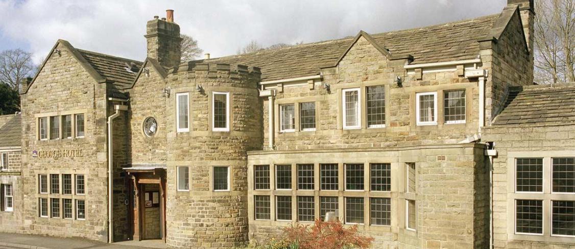
Continue straight along the road into the town. Follow the road through Hathersage and turn left at the junction opposite the George Hotel at the bottom of the hill (signposted for Grindleford and the David Mellor Cutlery Factory). On the edge of town, you will see a left turn signed Station Approach which leads to Hathersage Railway Station, where you can hop on a train back to your starting point.
New Mills Millennium Walkway, River & Canal Walk: 5 miles
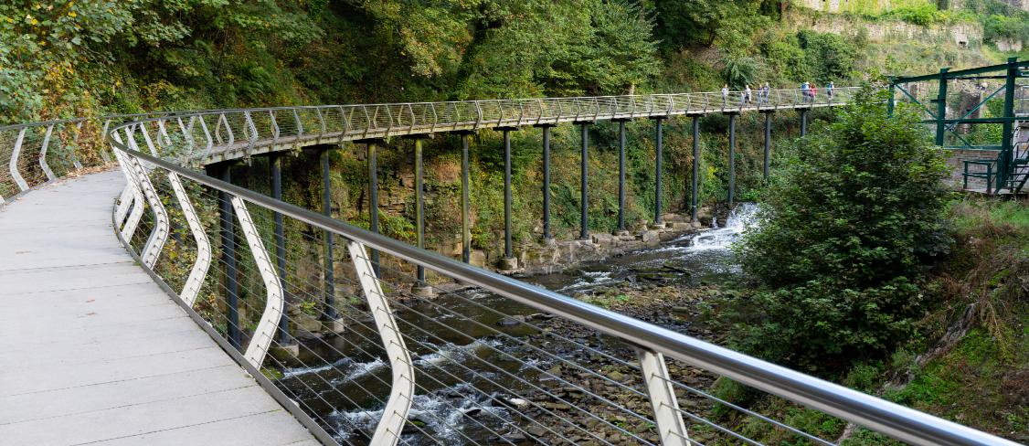
Close to Manchester and Stockport, the heritage-rich town of New Mills is situated in a dramatic position alongside the River Goyt and near to the Peak Forest Canal. From New Mills Central Station (on the Hope Valley Line - there’s also a station at New Mills Newtown on the Buxton Line), follow the trail along the Torrs Riverside Park and cross over the magnificent Millennium Walkway, a 160-metre long aerial walkway spanning the cliffside above the River Goyt. Soak up views of the dramatic railway arches, Torrs Hydro and bridge walkway, whilst looking out for information boards explaining more about the area's industrial heritage.
From Torrs Riverside Park, head south along the Goyt Way towards the canal. Follow the path west past Newtown and Brunswick Mill to Woodend, where you can rejoin the river and walk through the peaceful Mousley Bottom Nature Reserve. After passing through the nature reserve, you either head back to the main road and back to the station. For a longer walk, continue along the tranquil canal path towards Marple Canal Locks and hop on the train there.
Stay Peak District Proud: Help us keep the Peak District special for the next 70 years and beyond. Whether you live locally, or you're visiting for a day or two, ensure your visit is a responsible one by following our visitor charter. Stay #PeakDistrictProud by always sticking to the Countryside Code: remember to keep dogs on leads, take your litter home, don't 'wild camp', and never light BBQs or campfires, as they are a risk to public safety and the wildlife that live here.
Sign up to our newsletter
Receive the latest news, special offers, ideas and inspiration straight to your inbox by signing up to the Visit Peak District & Derbyshire e-newsletter.